 |

ROUTE MAPS
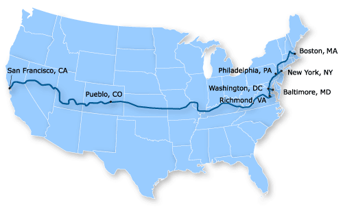
One of the most common questions we get is, "How did you plan your route?" The answer to that question is simple: we didn't have to! Adventure Cycling has a complete set of cycling maps that got us from San Francisco, CA all the way to Boston, MA without any guesswork or route planning necessary. These maps are extremely detailed and contain routes that are hand-selected by the cyclists at Adventure Cycling to be among the most safe, scenic, and enjoyable. In addition, the maps list camp sites, motels, restaurants, bike shops, and other services along the route, complete with phone numbers and addresses. The full set of cross-country maps are available from the Adventure Cycling online store. There are also many other sets of bicycling maps available for travels in other parts of the country. We thank Adventure Cycling wholeheartedly for this indispensable resource. The only planning we needed to do was to determine the next day's mileage based on the current travel conditions and accommodations available. Below is a map of our cross-country route.
Below is a list of some of the larger cities and sights that we visited as we traveled across the country (to the left), as well as the Adventure Cycling maps that we used (to the right):
CALIFORNIA
San Francisco, CA
Davis, CA
Sacramento, CA
Lake Tahoe, CA (nearby)
Carson Pass at 8,573 feet
NEVADA
Carson City, NV
Fallon, NV
Carroll Summit at 7,452 feet
UTAH
Cedar City, UT
Climb to over 10,000 feet
COLORADO
Lizard Head Pass at 10,222 feet
Montrose, CO
Gunnison, CO
Monarch Pass at 11,312 feet
Salida, CO
Pueblo, CO
KANSAS
Scott City, KS
Larned, KS
Hutchinson, KS
Newton, KS
Eureka, KS
Chanute, KS
MISSOURI
Farmington, MS
ILLINOIS
Chester, IL
Murphyboro, IL
KENTUCKY
Owensboro, KY
Bardstown, KY
Harrodsburg, KY
Berea, KY
VIRGINIA
Wytheville, VA
Lexington, VA
Warrenton, VA
WASHINGTON, DC
MARYLAND
Reistertown, MD
PENNSYLVANIA
Norristown, PA
NEW JERSEY
Stockton, NJ
NEW YORK
Pine Plains, NY
CONNECTICUT
Windsor Locks, CT
MASSACHUSETTS
Boston, MA
|
|
Adventure Cycling Maps:
Western Express Route, Section 1
Product #: BC-2101
San Francisco, CA, to Fallon, NV (308 mi.)
Western Express Route, Section 2
Product #: BC-2102
Fallon, NV, to Cedar City, UT (465.5 mi.)
Western Express Route, Section 3
Product #: BC-2103
Cedar City, UT, to Dolores, CO (447 mi.)
Western Express Route, Section 4
Product #: BC-2104
Dolores, CO, to Pueblo, CO (359.5 mi.)
TransAmerica Section 7
Product #: BC-1531
Pueblo, CO, to Alexander, KS (292 mi.)
TransAmerica Section 8
Product #: BC-1532
Alexander, KS, to Girard, KS (331.5 mi.)
TransAmerica Section 9
Product #: BC-1533
Girard, KS, to Murphysboro, IL (401.5 mi.)
TransAmerica Section 10
Product #: BC-1541
Murphysboro, IL, to Berea, KY (416 mi.)
TransAmerica Section 11
Product #: BC-1542
Berea, KY, to Christianburg, VA (393.5)
TransAmerica Section 12
Product #: BC-1543
Christiansburg, VA, to Yorktown, VA (369.5 mi.)
Atlantic Coast Section 3
Product #: BC-1443
Richmond, VA to Norristown, PA (384.5 mi.)
Atlantic Coast Section 2
Product #: BC-1442
Norristown, PA to Windsor Locks, CT (320 mi.)
Atlantic Coast Section 1
Product #: BC-1441
Windsor Locks, CT to Bar Harbor, ME (432.5 mi.)
|
|
 |